Huckleberry Mountain
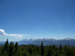
Posted by Jim Steele on July 14th, 2008 filed in Teton WildernessThe Huckleberry Mountain hike near Flagg Ranch offers you the chance to see – and camp in – a historic fire lookout that is no longer in use. From the top of Huckleberry, you’ll enjoy fantastic views of the Teton Range, Jackson Lake, and parts of Yellowstone National Park.

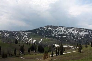
But the views come at a cost. Much of the surrounding area burned in the fires of 1988, so there is little vegetation to protect you as you gain 2,600 feet hiking to the summit. Much of the hike traverses steep, dusty ridges. The slopes, combined with the lack of vegetation, will make you work for every inch of elevation gain.
However, there is a bright side. It’s interesting to see the forest recovering. Many of the dead trees are still standing, but beneath, young trees, brushes and wildflowers are contributing to a new forest with a surprising variety of vegetation. Depending on the season, you might be treated to an impressive array of wildflowers. The experience of walking through these forests, with so many dead trees still standing, can be surreal, especially on a windy day. Regardless, it’s fascinating to watch the cycle of life begin anew.
View Larger Map
The views are one-of-a-kind. During the hike to Huckleberry Mountain, you’ll be able to see virtually the entire Flagg Ranch area with intermittent views of the Tetons. Once you get to the top, you’ll be in a unique position to see the Teton Range along with the mountains of southern Yellowstone National Park and the Teton Wilderness. Few hikes offer the chance to see both Yellowstone and the Tetons, but because this trail isn’t in either park, most guidebooks ignore it and you’re unlikely to see too many fellow backpackers.
To get to the trailhead, drive north of Jackson through Grand Teton National Park to the John D. Rockefeller Jr. Memorial Parkway and Flagg Ranch area, just south of Yellowstone. After you descend into the area, you’ll come to a marked road to Sheffield Creek. This junction is just before a bridge over the Snake River and the turnoff for Flagg Ranch. Turn right and follow the dirt road to a campground. Just before the campground, you’ll cross Sheffield Creek. There is no bridge, although concrete bars have been laid across the creekbed. Both times I’ve done this hike have been early in the season and the creek has been gushing, so I’ve left my car in the small parking area west of the crossing and walked to the trailhead, which only adds a few minutes to the hike. I would have been more adventurous in a truck, although I have seen cars parked at the trailhead.
On the other side of the creek is a small campground with an outhouse, horse corrals, and five campsites. The trailhead is on the south end and is marked with a large sign. The trail starts just to the left of the sign.
You start your adventure at approximately 7,000 feet above sea level. Just a few minutes past the trailhead, you’ll come to a junction. Turn right here. A sign marks the entrance to the Teton Wilderness. Due to the wilderness designation, this trail is closed to anything with wheels, although you might see people on horseback. The elevation gain starts in earnest here, and as you climb, you’ll see that the trail is badly rutted.
Before long, the trail will turn to the northwest and you’ll begin climbing a ridge with the Flagg Ranch area to your left and a tributary of Sheffield Creek to the right. Although the views are cool, this is one of the toughest portions of the hike. The trail is steep and fully exposed to the sun. No matter how much water you brought, this section will make you wonder if it’s enough. At some points during this segment, you’ll be able to see Huckleberry Mountain to the west.
The trail eventually stops following the crest of the ridge and your views of the Flagg Ranch area and Snake River will disappear. Approximately a couple of miles from the trailhead, you turn to the east and cross a creek. Next, you’ll walk through a spooky burned forest with armies of charred trees still standing. If you watch through the trees, you’ll catch glimpses of the Tetons. If you’re a photographer, this section offers a plethora of unique compositions. You’ll continue gaining elevation steadily through this stretch, although at a more forgiving grade than during the first couple miles.

After you leave the forest, you’ll descend to a creek crossing. Huckleberry Mountain dominates your view here. After you cross the creek, you’ll start climbing again, hopping a series of rivulets and – finally – entering into unburned terrain.

The trail will finally lead you to Huckleberry Ridge and the northeastern base of Huckleberry Mountain. The main trail passes the full width of the northeastern base, then continues south. To get to the top, you have to leave the main trail, but the spur route is in poor condition. About halfway along the base of the mountain, start bushwhacking toward what is obviously the most accessible route to the top. Eventually, you’ll intersect a series of switchbacks that lead to the top, at 9,615 feet above sea level – roughly 2,600 feet higher than the trailhead. Once you’re on top, a defined trail leads south to the lookout. You’re only a few minutes away.
The two-story building is a truly unique place. It hasn’t been used as a fire lookout for years but remains in place, against all odds, in a wilderness area. The building is in surprisingly good shape, and it is obvious that some groups provide at least minimal upkeep, as the glass windows are intact and the lookout is reasonably clean inside. Some of the old fire triangulation equipment even remains in place. You can camp in or around the building, and it is even possible to ski or snowshoe to the summit in the winter, camp in the lookout, and keep warm thanks to the wood-burning stove. Wooden coverings protect the windows, but you can lift them to open up the view.

From the lookout, the views are first-rate, particularly of the Teton Range and Jackson Lake to the southwest and Yellowstone National Park to the north. I spoke with a couple who said that on a clear day, you can make out the ski runs of Snow King. And for another unique view of the world, blaze a trail for the short distance to the northern end of Huckleberry Mountain. From here, you’ll be able to see much of the terrain that you just hiked through, along with the Snake River in the John D. Rockefeller Jr. Memorial Parkway.

A great deal of history marks the Huckleberry Mountain area. The fire lookout was built in 1938 and hasn’t been used officially since 1957. According to Rebecca Woods’ guidebook “Jackson Hole Hikes,” the Forest Service started removing various fire lookouts from the region around 1980, but a nomination led to the Huckleberry building being placed on the National Register of Historic Places. Woods also notes that the area was a haven for elk tuskers. Woods, a naturalist, offers a great description of the hike, including the history of the area, and I recommend her book without reservation.
In 2004, a 24-year-old employee of Signal Mountain Lodge was hiking in the area. He got lost and sadly died of hypothermia.
Note: The Huckleberry Mountain area is not shown on the Grand Teton National Park National Geographic / Trails Illustrated map. However, it is shown on the Old Faithful region National Geographic / Trails Illustrated map.
