Heart Lake and Mt. Sheridan
Posted by Jim Steele on September 6th, 2009 filed in Yellowstone National ParkIt’s easy for me to call a hike one of my “favorites.” After all, I’m usually just thrilled to be in the backcountry. But I can say without a doubt that one of my “favorite” adventures of the summer was the trek to Heart Lake and the summit of Mt. Sheridan in the south end of Yellowstone National Park. This challenging, 23-mile hike offers a backcountry geyser basin, a gorgeous mountain lake, and 360-degree views from the summit.

This is truly a uniquely Yellowstone hike, thanks to the Heart Lake Geyser Basin, which you’ll pass through en route to Heart Lake. I love exploring backcountry thermal areas, where there are no throngs of tourists and boardwalks getting in the way. But the hike offers more than just geysers. Heart Lake is one of the coolest backcountry lakes in Yellowstone. And the view from Mt. Sheridan is just incredible. You see numerous mountain ranges and lakes and absolutely no cities. A fire lookout on the summit takes advantage of the sweeping views.
View Larger Map
The caveat is that this hike is extremely difficult, especially as a day hike. Round-trip, the distance to the summit is about 23 miles and the climb from Heart Lake to Mt. Sheridan gains almost 3,000 feet in just over three miles. There are numerous backcountry campsites along the shores of Heart Lake and many backpackers do the trip to the summit as a day hike.
The trailhead is near Lewis Lake along the South Entrance Road of Yellowstone, about five miles south of the Grant Village Junction and 14 miles north of the South Entrance. It’s marked as the Heart Lake trailhead and there is ample parking and an outhouse at the trailhead.
From the trailhead, you are 7.5 miles from Heart Lake. From there, it’s another four miles to the summit of Mt. Sheridan. The first 4.5 miles of this trail are underwhelming. You’ll wander through forests, including some that burned in 1988, and through some smaller meadows that often support prosperous mosquito populations. You’ll notice that the soil has a gritty volcanic composition. The first leg of the hike does offer a chance to see the changes as the forest grows back in the wake of the fires.
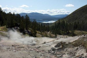
But after 4.5 miles, you’ll come to one of my favorite scenes on this hike, the view from the top of Witch Creek Hill. You’ll emerge from the forest to a point where you look out on Heart Lake, some 2 to 3 miles off in the distance, with a small thermal area right below you and a basin opening beyond. It’s the kind of setting that you’ll only find in Yellowstone.
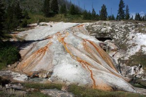
You’ll see Factory Hill to the southwest. Thus far, Factory Hill has blocked your view of Mt. Sheridan, but as you descend to Heart Lake, the summit, with the tell-tale fire lookout, will come into view. The trail descends about 700 feet from Witch Creek Hill to Heart Lake, passing more hot pools along the way. A few minutes off the trail, you’ll see a thermal area that looks like a miniature version of Mammoth Hot Springs. A “social” trail leads there. As you get closer to the lake, you’ll pass through a meadow then a backcountry ranger station. Just after the ranger station, you reach Heart Lake.
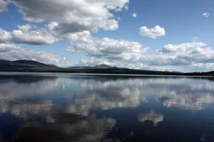
The pristine Heart Lake is truly a gem. It’s one of the largest lakes in Yellowstone and the view of Mt. Sheridan rising above the west shore is outstanding. It’s popular among backpackers and fishermen and the lake itself makes a fine day hike. This is one of the most remote areas of Yellowstone, and you’ll enjoy the solitude. The lake is at 7,455 feet above sea level, a few hundred feet below the trailhead, 700 feet below Witch Creek Hill, and 2,850 feet below Mt. Sheridan.
At the junction, one trail leads to the north and eventually reaches the South Arm of Yellowstone Lake. The south trail follows the west shore of Heart Lake, leading deeper into the Yellowstone backcountry and connecting with trails to the Thorofare region and the South Entrance. Turn right (south) if the summit of Mt. Sheridan is your goal; you’re 0.7 miles from the junction with a spur trail that leads to the top.

This trail follows the shore of Heart Lake, eventually crossing the runoff channel from Rustic Geyser, which lies just a few minutes off the trail and is also worth exploring. After a few more minutes, you’ll see a couple of the Heart Lake campsites. The junction with the trail to the summit is just after the second campsite.

From here, be prepared for some pain, agony, sweat and tears. The trail to the summit gains almost 3,000 feet over somewhere between 3.3 and 3.9 miles (my map doesn’t agree with the sign). The only redeeming qualities are that the views just keep getting better the higher you climb and that the elevation gain is reasonably evenly spread throughout the trail. Note that you’re walking primarily through burned forest and water is not available on the trail. For most of the climb, you’ll be looking to the north and east, seeing Heart Lake and Yellowstone Lake. But as you get closer to the summit, you’ll cross to the west side of the ridge and be treated with views south to the Tetons.
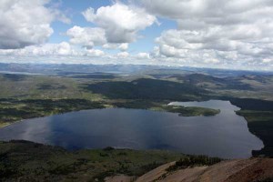
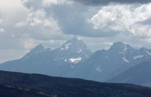
And when you make it to the top, all of the heartache will be worth it. You’ll be able to see all of Heart Lake, much of Yellowstone Lake, part of Shoshone Lake, and numerous smaller lakes. You’ll see the Tetons, Huckleberry Mountain, the Absaroka Range, and many of the other mountains of Yellowstone. The Pitchstone Plateau is visible to the west. And you won’t see a single city. In fact, with the exception of the patrol cabins at Heart Lake and the fire lookout, it’s tough to make out much evidence of development at all, which is one of the most refreshing aspects of this hike. You’ll feel like you’re deep in the wilderness, taking in a scene that is virtually unchanged from 100 years ago.
The fire lookout is an interesting old building. Until recently, a National Park Service employee spent a couple of months up here each summer, watching for fires in conjunction with lookouts on Mt. Holmes and Mt. Washburn. But the tower has been unstaffed the past couple of summers, its services largely unnecessary thanks to satellite monitoring. The building has been boarded up both times I’ve been at the summit. It’s interesting to think about what spending a summer in this lookout would be like. The sunrises and sunsets would be fantastic and waking up to the 360-degree view every day would be outstanding.
An outhouse is located at the south end of the summit. Someone with a sense of humor has installed a hook to prop the door open with the following instructions: “For full effect, latch door open.” The view from the outhouse, 3,000 feet above the surrounding terrain, is fantastic and the outhouse is positioned so that the effect is maximized when the door is open. A helpful person has also left a toilet plunger in the outhouse, just in case the pipes get clogged. There’s nothing like backcountry humor …
To get back, retrace your steps. If you’re doing everything as a day hike, keep a close watch on the time, as you have little to spare and you may want a few minutes to explore the geyser basin and need to leave extra time to make the 700-foot climb out of the Heart Lake basin. If you’re camping at Heart Lake, you’ll be glad to have more time to enjoy the truly incredible view.
Notes: The Heart Lake campsites are popular and the Park Service sometimes limits stay lengths. There are no campsites between the trailhead and Heart Lake. … Snow can linger on the mountain well into August and you probably wouldn’t have much like hiking up the mountain until well into July. … The trail passes through the Heart Lake Bear Management Area and could be closed in June. … And well-deserved pizza and cheeseburgers are available in Grant Village, 10 minutes north of the trailhead, after the hike.
Link: Heart Lake Trail, from Daryl Hunter’s Greater Yellowstone Resource Guide. Daryl has a much better discussion of the ecology of this area than I could ever hope to write.

October 29th, 2012 at 9:25 am
[…] been to Seven Mile Hole. You’ve summited Mt. Sheridan. And you’ve seen Union […]