
The Grand Canyon, Part 2: South Rim to North Rim
Posted by Jim Steele on August 17th, 2016 filed in Grand CanyonNOTE: This is my second article about my adventures in the Grand Canyon in the Spring of 2016. In April 2016, I hiked from the South Rim Village to Phantom Ranch and back. This article describes my May 2016 Rim-to-Rim hike from the South Rim to the North Rim. The article about my April hike to Phantom Ranch is here.
A Rim-to-Rim hike in the Grand Canyon is one of the truly iconic adventures in the national parks. We lived in Las Vegas for a year and while we were there, I wanted to check the Rim-to-Rim journey off my bucket list. Because who doesn’t want to hike 22 miles in a day while gaining more than a mile of elevation? My wife thought I was crazy, and she was probably right.
Unfortunately, the optimal season for this hike is short (basically mid-May to early June and mid-September to mid-October in order to avoid the worst of the heat at the base of the canyon and still make the trip while the North Rim Village is open). I hadn’t been able to plan anything in advance, so I was crossing my fingers that I would be able to put an adventure together at the last minute in the second half of May. But the logistics of a Rim-to-Rim hike are challenging at best. You generally need somewhere to stay on the South Rim, somewhere to stay on the North Rim, and transportation for the circuitous four-hour drive that links them. Reservations at the lodges, naturally, tend to fill up quickly. And it would be a shame to get everything planned and then be rained out.
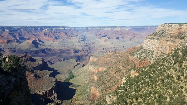
The view from the Bright Angel Trailhead. The trail to Plateau Point is visible near the center of the photo.
My trip started off with a burst of luck. Motel rooms in Williams were fairly expensive so I had booked an economy room. I checked for last minute specials and was able to get a room at the Grand Canyon Railway Hotel for the same price. This hotel is massive (by Williams standards), is reasonably new, and seems to exist to house tour groups that arrive in town before they set off for the South Rim, 60 miles to the north, via the Grand Canyon Railway. The hotel was pleasant, my room was comfortable, and I got to see some of the train memorabilia that is scattered around the property. I was a happy camper. Williams is the last town of any significance before you arrive at the South Rim Village, about an hour to the north (excluding the tourist trap town of Tusayan), so I stocked up on supplies at the Safeway, headed back to my hotel, ate dinner, packed my backpack, and got to bed at sunset in anticipation of an early departure the next morning.

Switchbacks along the Bright Angel Trail.
I carefully began descending via switchbacks that are carved into the side of the canyon and can accurately be described as engineering masterpieces. I passed the Mile and a Half Resthouse and the Three Mile Resthouse without incident and saw plenty of people along the way – this was a Saturday in May, and there were numerous other people who wanted to explore the Grand Canyon. And I saw the trail to Plateau Point in the distance, remembering one of the most awe-inspiring places I had visited the month before. Finally I arrived at the Indian Garden Campground, where I refilled my Camelbak with the fresh water that is piped in by the National Park Service. The trailhead for Plateau Point is at Indian Garden Campground, but there was no time for that side trip today.

A blooming cactus.
After 7.5 miles, I finally reached the Colorado River at Pipe Creek Beach. Having taken both trails, I was able to conclude that the views from the South Kaibab Trail are definitely more sweeping than the views from the Bright Angel Trail, but that both make for an awe-inspiring trip into the Grand Canyon. After dipping my hands in the water and taking a selfie, I was back on the trail for the hike to Phantom Ranch, where I planned to have lunch. This section of the hike is very pleasant – the trail undulates along the shores of the Colorado River, giving you plenty of time to contemplate the forces that carved the dramatic canyon. But it was at this point that the magnitude of what was ahead of me – 14.5 more miles of hiking and about 6,000 feet of elevation gain – started to hit me. It made it harder to enjoy the setting.
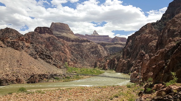
The Colorado River at the base of the Grand Canyon. Both footbridges are visible.

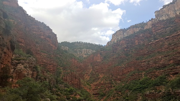
A section of “The Box.”
The problem is that for eight miles after Phantom Ranch, the elevation gain is very gradual and you gain “only†2,000 vertical feet as you hike through The Box, pass a short spur trail to Ribbon Falls, pass the Cottonwood Campground (which seemed like it would have been a great place to camp; note that seasonal water is available), and finally arrive at the Pumphouse and the residence for its caretaker. As this was my first Rim-to-Rim hike, I kept wondering when the real work would begin and just how bad it was going to be. I found out when the trail split from the Old Bright Angel Route, took a turn to the northwest, and began gaining elevation very quickly. From this point, you gain 3,700 feet over about four miles. Fortunately, the views distracted me from the misery. This section of the trail is comparatively lush (especially compared to the desert-like segments near Phantom Ranch), with more trees. The colors are also striking. I was taken aback by the deep reds of the canyon walls, particularly their sharp contrast with the trees. It’s a different experience from the base of the canyon, and a different experience from the South Rim.
The climb to the North Rim.
And, fortunately, my adventure wasn’t over. Trans-Canyon Shuttle generally offers two shuttles per day from the North Rim to the South Rim (one shuttle per day in the second half of October) and I had scheduled the late shuttle (leaving at 2 p.m.) in order to give myself some time to explore the North Rim area. But first I had to get to my cabin. The North Rim Lodge is located about two miles from the North Kaibab Trailhead via the Bridle Trail. While most people would probably ask someone for a ride, I chose to walk. I arrived at the Lodge after sunset, quickly registered, and took a minute to enjoy the view of the Grand Canyon from the great room of the Lodge. It was a postcard view and I was glad I would have some time to explore the next day. I felt that the views from the North Rim were even better than the views from the South Rim, likely helped by the fact that the North Rim sits 1,400 feet higher than the South Rim, but also assisted by favorable topography.

The North Rim Lodge.

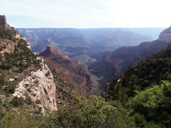
The view from Bright Angel Point.
A view from the Transept Trail.

A Pueblo foundation along the Transept Trail.
Then at 2 p.m. my shuttle left to return to the South Rim via Jacob Lake, Marble Canyon and Cameron. Our driver pointed out many of the sights along the way, and one of the highlights was the view of the Vermillion Cliffs. By around 6 p.m., I was back at my car, thrilled with my trip but sad that it was over. I will never forget my Rim-to-Rim hike.
Note: As I wrote in Part 1, I have only hiked the Grand Canyon twice and don’t claim to have any particular expertise. However, I learned a lot while researching this trip and had a great time, so I am sharing this article in hopes that someone can benefit from my experiences. There are plenty of ways to experience the Grand Canyon and there is no shortage of information online. Remember that what worked for me may not work for you. With that said, here are a few more notes:
- The Park Service bends over backwards to advise people not to hike Rim to Rim in a day, or to hike from the Rim to the Colorado River and back in a day. While I have no doubt that this advice is appropriate for 99 percent of visitors, it obviously doesn’t mean that a Rim-to-Rim hike can’t be done. Whatever adventure you are planning, know your limits and make sure you factor in the variations in weather between the North Rim, South Rim and Phantom Ranch.
- Having hiked down via both the Bright Angel and South Kaibab trails, the views from the South Kaibab Trail definitely are better than the views from the Bright Angel Trail. But the Bright Angel Trailhead is somewhat more accessible and the availability of water along the Bright Angel Trail is a major selling point.
- Service from the Trans-Canyon Shuttle was outstanding. My shuttle left on time and arrived early. The driver made sure to point out notable landmarks along the way and never got tired of our questions.
- Remember that hiking from the South Rim to the North Rim entails 1,400 more feet of elevation gain than hiking from the North Rim to the South Rim. If you have any doubts about whether you are ready for this trip, go from North to South.
- If you don’t want to go all the way to the Colorado River, day hikes to Supai Tunnel (from the North Rim) or to Plateau Point (from the South Rim) are also great options. Even these hikes, however, can be challenging; know your limits.
- Cell coverage at the North Rim is hit and miss. It seemed to be overflow coverage from the South Rim, so don’t expect a strong signal.