Hidden Lake in Glacier National Park
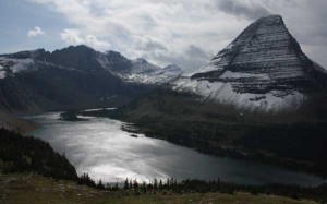
Posted by Jim Steele on October 5th, 2008 filed in Glacier-Waterton International Peace ParkSo far I’ve been writing about trails in northwestern Wyoming, primarily in Yellowstone and Grand Teton National Parks. I’m making an exception for Hidden Lake in Glacier National Park, which has to be one of the most gorgeous places on the planet. The long, crescent-shaped lake is tucked amongst the jagged, glacially carved peaks of Glacier National Park with pristine waters that seem to invite you to stay for a while.

Even better, it’s a reasonably easy hike, starting at the top of the Going to the Sun Highway behind the Logan Pass Visitor Center. You’ll gain about 500 feet of elevation over 1.5 miles hiking to the Hidden Lake Overlook, where you top out at about 7,125 feet, then lose about 750 feet as you hike another 1.5 miles to the shores of the lake. The hike out can be a challenge for less experienced mountaineers, so be aware of the climb that awaits you.
View Larger Map
Glacier National Park is an experience totally unlike Yellowstone and Grand Teton parks. In Glacier you truly get the sense of being surrounded by jagged, glacially carved mountains on every side – even though the West Entrance of Glacier is only 34 miles from Kalispell, Montana, you can hike through the park and not see the surrounding valleys in any direction. The hikes through the Tetons are a different experience entirely – on the top of Paintbrush Divide, for example, you’ll see the farmland of Idaho to the west and Jackson Hole to the east. And in Yellowstone, although you can get the experience of being completely surrounded by mountains, you’ll never see so many peaks as jagged as the ones in Glacier.
To get to the trailhead, drive to the top of Logan Pass from either the west or east entrances to Glacier. From West Glacier, it’s 32 miles, and from East Glacier, it’s 18 miles. The Going to the Sun Highway is an interesting experience in itself. In so many places, it’s literally carved out of the side of the mountain. The steep, narrow, winding highway is closed to long RVs – with good reason – and is only open for about four months each year. Even if you’re not going to hike, you can still get a great sense of the distinct Glacier landscape from this road.
The trail starts behind the Logan Pass Visitor Center. It begins by gaining about 500 feet climbing to Hidden Lake Divide via a combination of pavement, boardwalk and dirt trail. As you climb, the steep walls of Mount Oberlin dominate the view to the north. Â During this segment of the hike, you’ll be able to see down both sides of Logan Pass and might catch a quick glimpse of the west end of St. Mary Lake to the east. The growing season at this elevation is short and the trees are short. You could be treated to a wildflower show, however. You’ll also see some cascades along the trail.
After a little over a mile, the trail will level off and you’ll see a small pond south of the trail. After 1.5 miles, you reach the overlook – which is a worthwhile hike all in itself. You can see almost all of Hidden Lake from here, with Reynolds Mountain rising to the south and Bearhat Mountain rising right above Hidden Lake. The view is breathtaking and at this point, the urge to hike down to Hidden Lake is almost irresistible.

The trail continues for 1.5 miles to the lake, with some switchbacking. You’ll drop 750 feet from the overlook down to 6,375 feet above sea level. Along the way, you’ll see the tip of Lake McDonald in the distance. And watch for mountain goats – this is prime habitat for these fascinating animals. One time at Hidden Lake, a mountain goat started following my brother around for just a minute.

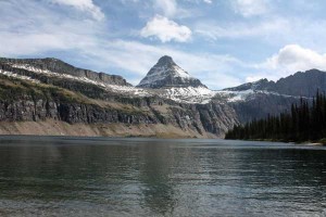
Once you get to the lake, you’ll wish you could build a cabin on the shores and stay for a while. The waters are pure, the only traffic you’ll hear is an occasional helicop-tour above, and jagged cliffs and mountains rise dramatically above the lake. It’s one of the most gorgeous settings I’ve ever been to.

The season for this hike is fairly short. Going to the Sun Highway may not open until sometime in June and the conditions on Logan Pass can be windy, cold and miserable – even if the weather is calm and pleasant in the lower reaches of the park. I’ve done this hike in July and it was unbeatable. I’ve been at the top of Logan Pass in late September and it was so blustery we climbed right back in the car. However, this year we hiked this trail in late September and had a great time, although there was some new snow hugging the trail and the day was very windy. I’ve never visited the area in June but suspect this hike remains inaccessible for much of the month and you could encounter some snow even in July.
Unless you’re a hard-core climber, the trail ends at Hidden Lake. No camping is allowed at Hidden Lake and fishing is catch-and-release only. Also, be aware that this is an extremely popular trail. If you’re hiking it in July and looking for solitude, you probably want to get a very early start – even on our most recent hike in late September, we saw a dozen or so people down at the lake.
Glacier National Park has about 700 miles of trails. Hidden Lake is a great way to explore three miles worth of the incredible hiking network.Â
Links
Logan Pass trails (Glacier National Park official site)
Going-to-the-Sun Road information (Glacier National Park official site)
