
Jackson Peak
Posted by Jim Steele on August 28th, 2013 filed in Gros VentresAt 10,741 feet, Jackson Peak dominates the skyline across Jackson Hole to the southeast from much of the Teton Range. From the summit, you’ll feel like the King of Jackson while you take in sweeping views of the Tetons to the northwest and the vast Gros Ventres to the east. At 5.3 miles each way with 2,500 feet of elevation gain, Jackson Peak makes a perfect day hike.

Jackson Peak (on the far left) above Goodwin Lake on August 17, 2013.
Plus, the trip has a bonus: You’ll pass by the beautiful Goodwin Lake about halfway to the summit. Surrounded by forests and a minor peak, Goodwin Lake is a fantastic place to stop for a break, camp, or jump in for a swim (assuming that you’re not deterred by ice-cold waters).
Even better, the trailhead is only 10 miles from the town of Jackson and, at an elevation of 8,200 feet, you gain plenty of elevation before you even leave your vehicle. Start at the beginning of the Elk Refuge Road at the east end of Broadway Avenue. Stay on the Elk Refuge Road for 4.6 miles, then turn right toward the Curtis Canyon Campground. At 6.0 miles you’ll begin a steady climb up a hill above the Elk Refuge. Continue past turnoffs to the Curtis Canyon Viewpoint and Curtis Canyon Campground at 7.2 miles until you reach a “Y†junction with Sheep Creek Road at 8.9 miles. Turn right and follow the exceptionally rough road until it ends at the trailhead after 1.0 more mile.
You’ll quickly begin hiking up a hillside covered by sagebrush and wildflowers that are likely to be in bloom early in the season and where you’ll catch glimpses of Jackson Peak to the south and the Tetons to the northwest. After a moderately steep section, the trail reaches a canyon rim above Sheep Creek at 0.8 miles. The grade moderates and you follow this rim south for about two miles, spending much of the time in forest but enjoying an occasional view of the Tetons.
At 2.4 miles, you come to a Gros Ventre Wilderness sign and the trail jogs to the east of a hill. If you look behind you, you’ll catch some cool views of the canyon to the north. At 3.0 miles, you cross a small creek and at 3.1 miles you arrive at Goodwin Lake.

Goodwin Lake, photographed August 17, 2013.
Plenty of people hike no farther than Goodwin Lake. A gorgeous alpine cirque at an elevation of 9,500 feet, the lake is popular with both campers and fishermen. You might not have solitude here (the proximity to Jackson and the modest distance make it a popular hike), but you’ll definitely enjoy the scene.

Goodwin Lake, seen from the south shore on September 29, 2010.
You’re 2.2 miles from the summit. You hike along the east shore before beginning a moderately steep climb into meadows directly below Jackson Peak. These rolling meadows are an underappreciated section of the hike. You’ll start to get a few glimpses of the vast Gros Ventre range while you walk along the eastern base of Jackson Peak. You feel like you’re a thousand miles away from civilization, when in reality, the east edge of Jackson is only six miles away as the crow flies.
After you’ve walked through the meadows, you reach an unmarked junction at 4.5 miles (from the trailhead) just before the trail reaches a minor crest and begins heading downward toward trails to Cache Creek and Turquoise Lake. The junction is usually marked with a cairn. Turn to the right. This is where the real work begins; in 0.8 steep miles you’ll be at the top after approaching the summit from the south.

The Tetons seen from Jackson Peak on September 29, 2010.
And what a view! The summit is well above the forest, so there’s nothing to keep you from feeling like you’re on top of the world. All you’ll see to the northeast, east and southeast are the Gros Ventres, including Cache Peak and Sleeping Indian. To the northwest, you’ll see the Tetons and Jackson Lake. Ironically, you can’t see much of the Town of Jackson from Jackson Peak, although the area below High School Butte is visible. Watch for the green roof of the Goodwin Lake ski cabin in the forests south of the lake.

Sleeping Indian / Sheep Mountain seen from Jackson Peak on August 17, 2013.
Jackson Peak can also be part of some longer itineraries. A connection is available to the trails that lead from Upper Cache Creek to Turquoise Lake, so it’s possible to hike up Jackson Peak from the Cache Creek Trailhead. That would be an exceptionally long day (approximately 30 miles), but you could shorten the adventure by mountain biking up Cache Creek and leaving your bike at the wilderness boundary. You could also shuttle a car to the Goodwin Lake Trailhead.
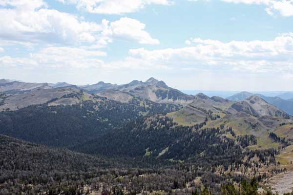
The Gros Ventres seen from Jackson Peak on August 17, 2013.
In addition, campers with a car shuttle sometimes start at the Goodwin Lake Trailhead, camp at Turquoise Lake, then emerge at Granite Hot Springs the next day, wrapping up their trip with a relaxing soak.
Notes: These trails are popular with dog owners. … Be alert; these trails lead through prime bear country. … Once you leave Broadway, the entire route to the trailhead is on gravel roads. Most are in reasonably good shape, but the final mile is exceptionally rough. You may be able to get to the trailhead in a regular car, but a wagon with higher clearance or a truck is highly recommended. … Don’t confuse this Jackson Peak with the one in the Wind River Range. … Snow likely lingers on this trail well into July.